CleverMaps vision and goal
We strongly believe that important decisions should be made with information backed by reliable data. We also believe there is unutilized but valuable information lying in geospatial data. Thirdly, we believe data analysis should be a continuous process integrated into company processes. And finally, we believe a lot of resources are saved if technology is used right especially for repetitive continuous processes.
Traditionally geospatial data analysis is done by GIS software. However, we see GIS is not catching up with modern data analysis trends. Compared to modern BI tools (Business intelligence) they lag behind. They became complex, hardly manageable, and difficult to learn. A skilled specialist is needed to operate them. They are unsuitable for continuous analysis. Those properties make them unnecessarily expensive and time-consuming.
On the other hand, important geospatial features are missing in BI tools. They can't work with map layers. They lack expressive map visualization. Their engines are not able to compute join or filter data by geospatial attributes. Those missing features make BI tools unsuitable for use cases like Network expansion and Network optimization, Delivery zones planning, Site evaluation, Advertisement planning etc.
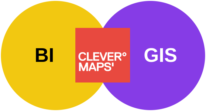
CleverMaps is a family of products which work smartly together to fulfil a common goal - to continuously deliver valuable information backed by geospatial data to make informed decisions. We implement this goal by bringing technology following ideas verified by modern Business intelligence stacks into the geospatial analysis. Shortly CleverMaps is a Location intelligence platform.
More about what CleverMaps is useful for see Solutions on our web CleverMaps↗
Location intelligence process
LI could answer a simple one-time question or it could be answering comprehensive questions continuously. We believe more questions will always come. So it is worth investing in a reusable infrastructure (data stack) which pays off many times over. Because of this, we split our goal into 6 intermediate outputs.

Each of the outputs is reusable and is used by subsequent outputs. This setting saves a lot of effort when a new request comes because most of the work is reused.
Intermediate outputs are also handy for splitting responsibilities across a team or multiple teams. Each role is responsible for its own output. Note each company has its own setup, roles are named differently, they may overlap or concentrate into a single person. We believe it would be rather confusing to name them. So we reference them as “person who prepares data“ or “person who defines metrics“ etc.
Earlier outputs are more reusable, however, later outputs are easier to manage. It brings another advantage to this infrastructure. Specialized engineers prepare only the most-early outputs. Ordinal analysts reuse them and build later outputs. It saves human resources, money and time.
The foundation of each LI process lies in the dimensional data model which is formed by dimensional and fact tables. Dimensional tables can be easily reused between many projects and you will typically use already prepared ones. Fact tables are usually project-specific and need to be transformed from raw input data by implementing a custom data pipeline.
More about what is Location Intelligence in Location Intelligence
CleverMaps platform
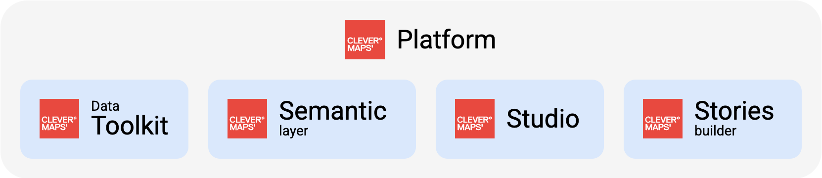
CleverMaps platform consists of five products which follow the previously described ideas. Thanks to that products fit natively into the process of work.
Each of the products can work independently and is ready to be integrated with custom software. It is possible to make custom dashboards on top of the Semantic layer or embed Studio Map Dashboards into a custom web page.
Even though products can be used independently, there are some common cross-product features like authentication, access management, configuration metadata etc. We refer to them as platform-wide features and they have their own documentation page tree.
More about the platform, products and how they work together in CleverMaps Platform
More about how products integrate into your environment in Modern Data Stack overview
Data Toolkit
Data or feed transformed data into a Data model. These components are supposed to be integrated into your existing data pipeline stack, not to replace it. Usually, you will implement the data pipeline using your favourite data tools (SQL, Python, dbt, ...), and our components are here to help you with specific tasks.
Semantic layer
Data model,which manages Metric definitions, computation of metric values and caching. The Semantic layer can manage the data model so Data can be filled directly into it or connected to the external data warehouse. The semantic layer is controlled by a command line tool called CleverMaps Shell. All tasks can be performed with provided REST API, which is also used to query the values of a metric. Among others to be consumed by CleverMaps Studio and its Map Dashboards.
Studio
Map dashboards. Think of them as reusable group of interactive charts, values and map layers which visualizes given Metric. Values can be filtered, based on available attributes, metrics, polygons or distance. All values are computed ad-hoc on top of single Data model without need to use SQL. All together Studio allows to assemble data applications which can be directly shared or presented to managers to support their decision or is used to build Stories.
Stories builder
Stories. Think of a Story as an interactive document consisting of text, charts, Map Dashboards and filters. It is meant to be used to present the results of the analysis. Using available Map Dashboards, describe findings, correlations, fluctuations, peculiarities, etc. So managers can gain easy-to-digest information and make Informed Decisions.
How to read this documentation
We believe it is rare that a single person manages the whole data stack. Because of it, we slice our documentation based on the same pattern. Slices are named after the products described above. So each team role can dive into slices only relevant to them and not be overwhelmed by information irrelevant to the role. However, if you are an all-in-one person, no problem, follow the described roles. On top of it, there is a Getting started section which contains overview articles and describes common knowledge like this page itself and Platform, which describes common cross-product features.
Each slice follows the Diátaxis documentation system↗. Shortly articles are divided into four categories:
-
Explanation/Overview (understand) - Helps newcomers to understand concepts and context.
-
Tutorials (learn) - Leads newcomers to learn basics through a series of steps.
-
How-to guides (reach goal) - Leads user to complete a specific task through a series of steps.
-
Reference (information) - Gives users complete and accurate information about software parts.
We believe this division will help you find your way around.
We are determined to improve this documentation. That is why we need you! Please let us know if you find bugs, hard-to-understand sections or if you miss some information. Send your feedback to product@clevermaps.io or use the chat in the bottom right corner.
Continue to CleverMaps Platform